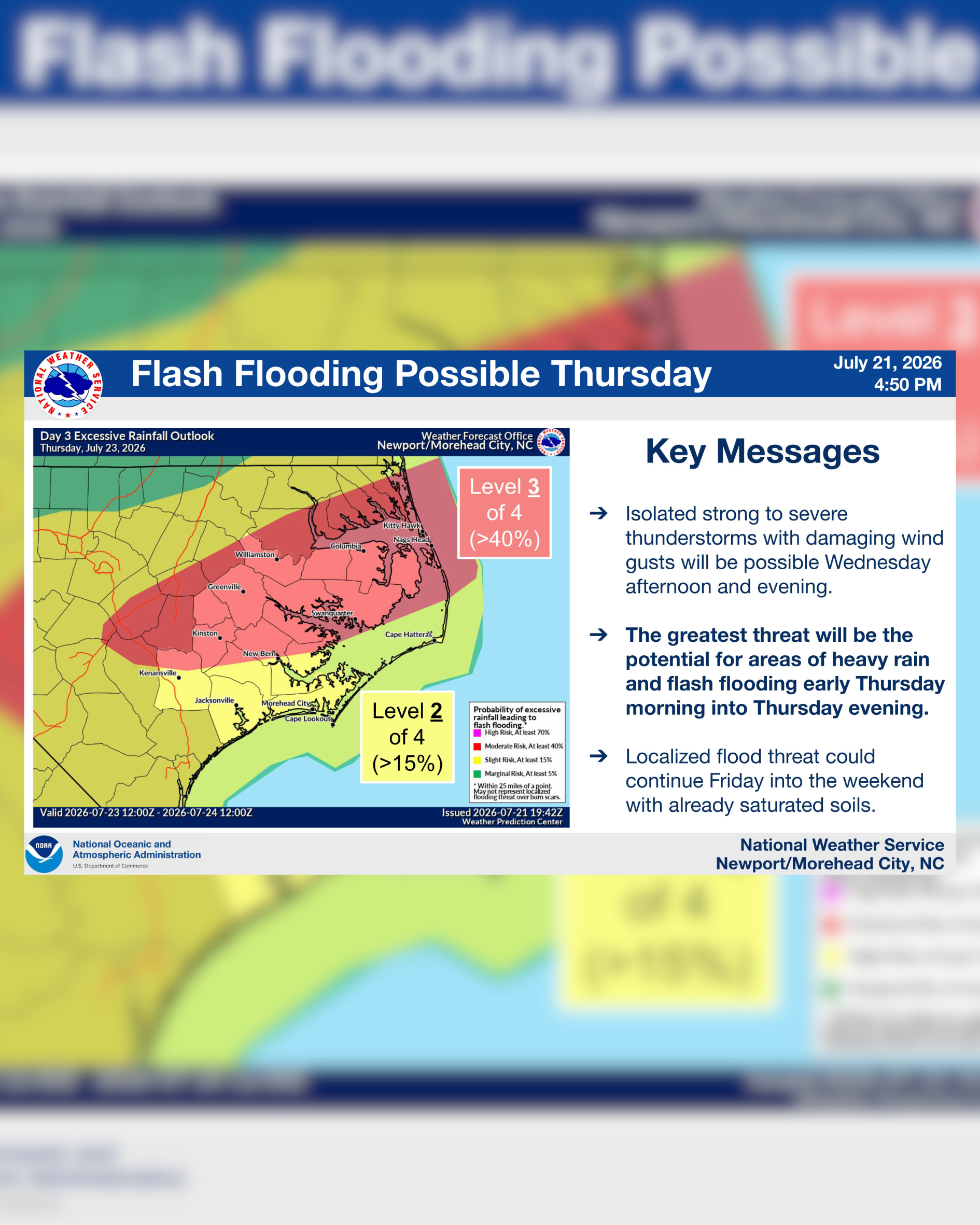
Isolated strong to severe thunderstorms with damaging wind gusts will be possible Wednesday afternoon and evening.
All tagged weather
Isolated strong to severe thunderstorms with damaging wind gusts will be possible Wednesday afternoon and evening.
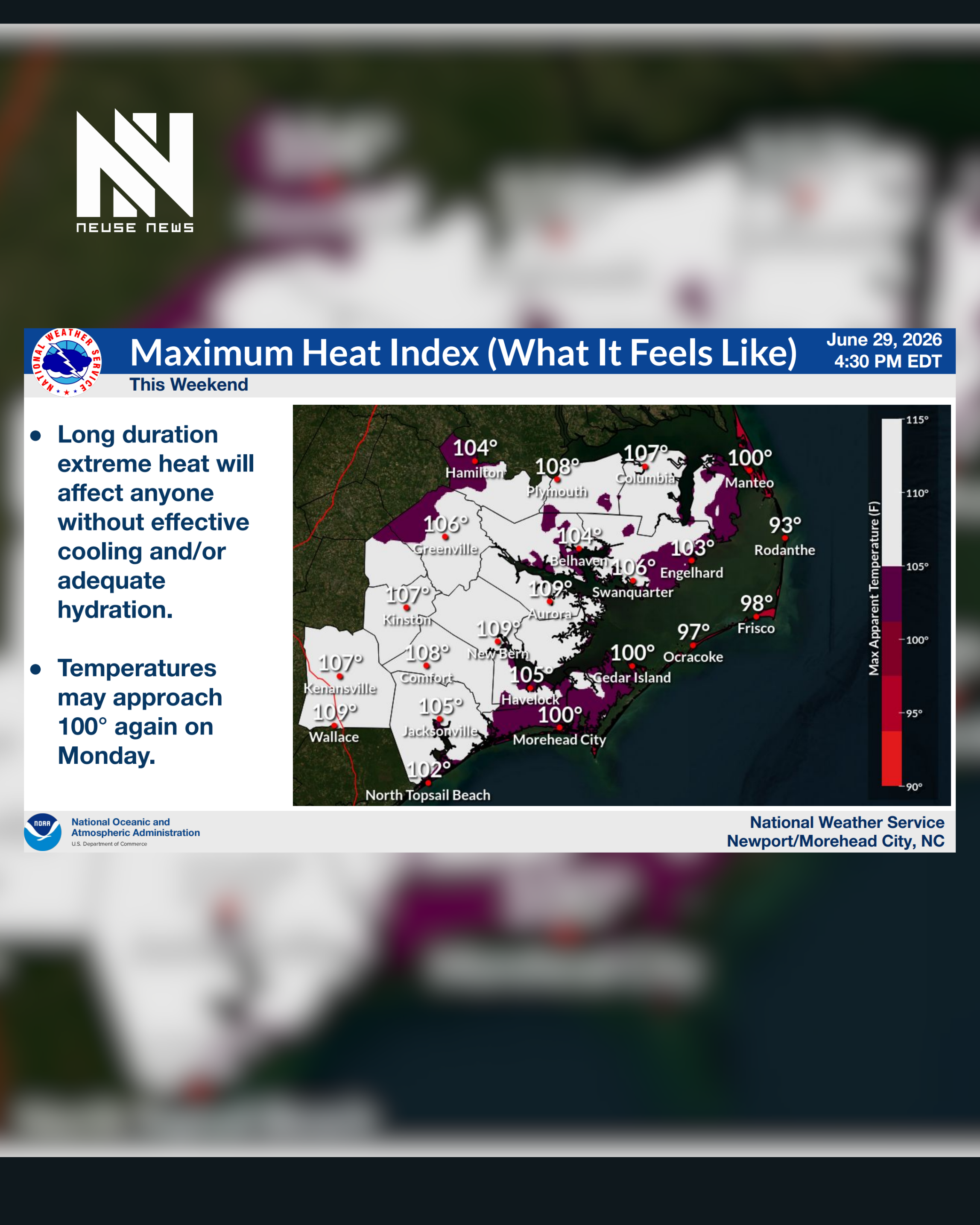
Temperatures will once again be well into the 90s today, with heat indices (what it feels like), around 105°.
This will be prolonged and expected to have extreme impacts for the majority of our area this weekend, coinciding with the 4th of July celebrations.
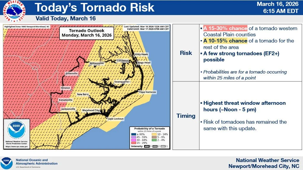
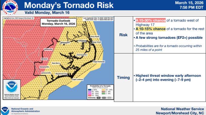
The National Weather Service in Newport/Morehead City warned Monday that severe thunderstorms remain a threat across Eastern North Carolina on March 16, with forecasters calling it a potentially significant severe weather event.
The threat for severe thunderstorms continues for Monday, March 16. This has the potential to be a significant severe weather event. In addition, there remains a marginal risk of severe thunderstorms this evening and overnight. Attached is the latest briefing for this event.
The Lenoir County Board of Education approved a calendar adjustment at last night’s meeting to provide additional flexibility later in the school year should inclement weather occur.
On Wednesday rain is expected. That combined with high temperatures well into the 40s, we should get some good melting. Unfortunately colder air moves back in overnight Wednesday into early Thursday.
Mayor Kareem Moore has issued a modified Declaration of a State of Emergency for the City of Kinston that includes limited restrictions and prohibitions, including an overnight curfew.
Winter Storm Watches have been upgraded to Winter Storm Warnings for all of eastern NC with the potential for significant accumulating snow.
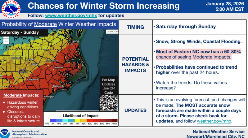
We continue to hone in on the potential winter storm this weekend. While it remains too early for specific snow accumulations, the likelihood of at least moderate impacts is growing.
(RALEIGH) Governor Stein declared a State of Emergency as North Carolina prepares for the impacts of a major winter storm. On Thursday, January 22, at 11:15 a.m., Governor Stein will hold a media briefing to provide updates on the status of storm preparations. He will be joined by NC Department of Public Safety Secretary Jeff Smythe, NC Department of Transportation Secretary Daniel Johnson, NC Emergency Management Director Will Ray, NC State Highway Patrol Colonel Freddy Johnson, and NC National Guard Major General Todd Hunt.
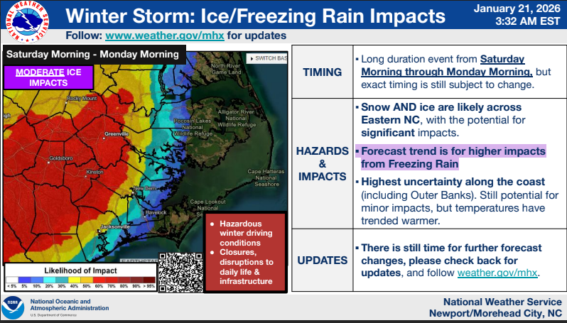
The biggest changes this morning are increased confidence in ice and freezing rain impacts, and lower probabilities of snow impacts for most, except those along and north of US 264.
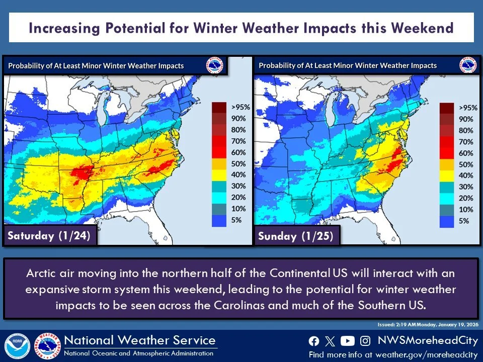
Chances are increasing that we could see winter weather impacts this weekend as an expansive storm system moves across the Southern US and interacts with Arctic air.
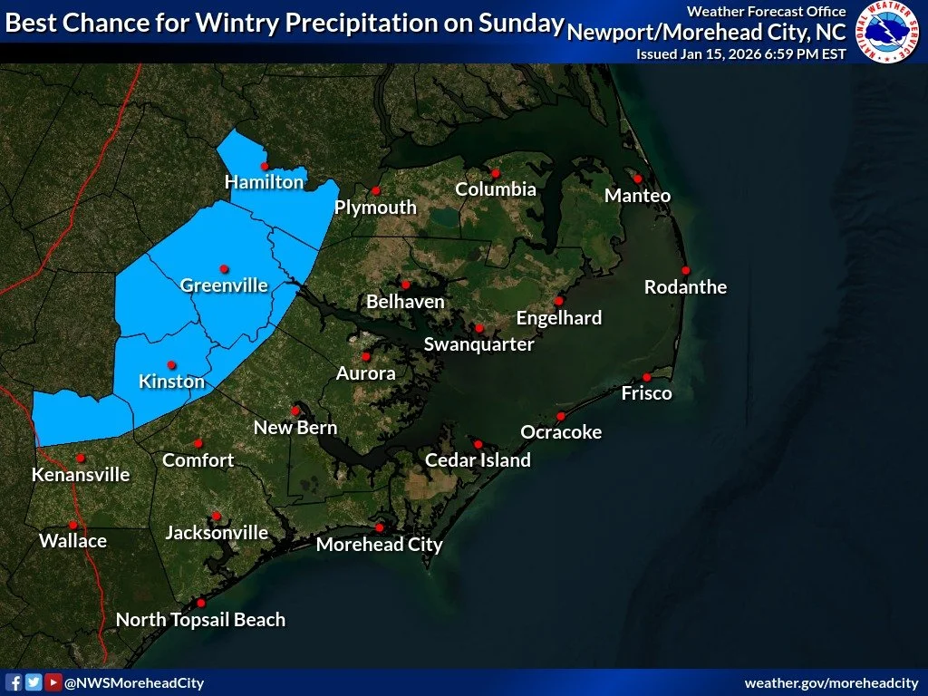
There's still a lot of uncertainty with the potential for wintry precipitation on Sunday. The trend in the models has been towards more rain rather than accumulating snow for the majority of ENC. However, areas west of Highway 17 have the highest chances at seeing wintry precipitation.
Due to weather conditions, the Lenoir County Courthouse and all divisions within, will open at 10:30 a.m. tomorrow, December 9, 2025. Court proceedings will resume at 11:00 a.m.
Potential for wintry weather continues to look marginal for tomorrow, with the greatest risk being across extreme western Pitt and Martin Counties from 4am - 9am Friday morning.
Heavy rainfall is expected to accompany this system, especially for immediate coastal locales where some embedded thunderstorms are possible. Up to 2" with locally higher amounts are forecast here, with 1-2" elsewhere.
The main hazards will be damaging wind gusts (60+ mph) and large hail, but an isolated tornado cannot be ruled out.
The National Weather Service (NWS) is warning of strong storms and hazardous conditions as a cold front moves through Eastern North Carolina on Wednesday.
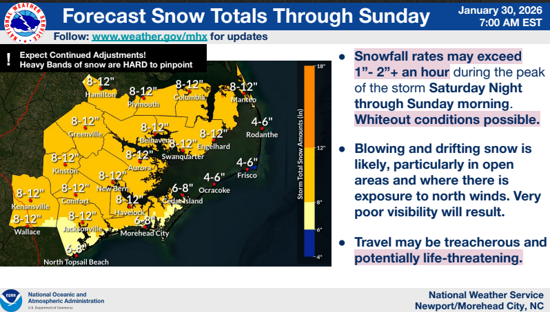
***Snowfall amounts have continued to trend upward***, and there is high confidence that we will see accumulating snow across all of Eastern NC starting after sunset tonight and lasting through tomorrow morning. Blowing and drifting snow is expected, and brief blizzard conditions are also possible, especially along the Outer Banks.
Local news delivered to your inbox every day at 7am. Free, always.