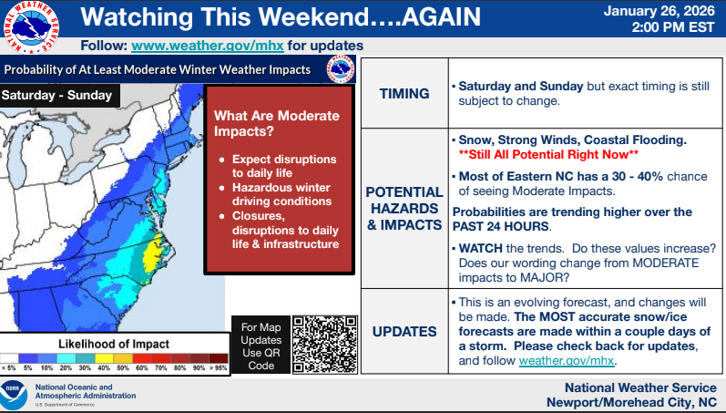
While it is WAY too early for too many specifics, the trend continues to increase that we may see at least moderate impacts in our area.
All tagged nws
While it is WAY too early for too many specifics, the trend continues to increase that we may see at least moderate impacts in our area.
A Winter Storm Warning and Winter Weather Advisory have been issued for most of Eastern North Carolina as a significant winter storm is expected to bring snow, sleet, and freezing rain starting tomorrow and continuing into early Thursday.
***Snowfall amounts have continued to trend upward***, and there is high confidence that we will see accumulating snow across all of Eastern NC starting after sunset tonight and lasting through tomorrow morning. Blowing and drifting snow is expected, and brief blizzard conditions are also possible, especially along the Outer Banks.
The National Weather Service (NWS) confirmed a tornado event in Kinston. “A brief tornado embedded within a large line of severe thunderstorms briefly touched down in the eastern portion of Kinston…” NWS said in their public information statement.
Strong winds are expected along coastal areas through tomorrow evening causing potentially minor damage and isolated power outages.
Newly-formed Tropical Depression 9 is moving slowly west through the central Caribbean Sea. TD 9 is forecast to turn north through the western Caribbean Sea early next week and strengthen into a hurricane as it moves into the southeastern Gulf of Mexico. Impacts to eastern North Carolina from TD 9 are possible late next week, but will be highly dependent on the eventual track.
Tropical Storm Colin formed this morning along the central coast of South Carolina. TS Colin will move northeast along the NC coast today through Sunday, bringing with it a variety of impacts including locally heavy rainfall, potential for isolated tornadoes, and gusty winds, especially along the coast.
The National Hurricane Center is monitoring this closely and currently has the area outlooked in a 80% probability of formation.
Another round of showers and thunderstorms are expected to begin today and into the afternoon. A few storms could become severe, with the main threats being heavy rainfall and gusty winds.
A tornado watch has been issued for parts of Maryland, North Carolina and Virginia until 8 PM EDT.
Final briefing regarding heavy rain tonight and Thursday, as well as overnight severe weather potential. The primary risk is damaging winds, but an isolated tornado cannot be ruled out. A Slight Risk of severe weather remains for all but the Outer Banks.
The National Weather Service in Morehead City/Newport is monitoring the potential for accumulating snowfall across much of eastern North Carolina Friday night into Saturday.
Low pressure passing off the coast will likely bring rain to the area Friday, transitioning to snow as temps drop into the upper 20s to lower 30s Friday night and Saturday morning. There is still significant uncertainty with respect to the snowfall amounts and coverage, but areas further north currently look to have the more favorable conditions for snowfall accumulation.
Snowfall amounts and timing details will come into better focus over the next day or so.
There is still some uncertainty with exact ice, sleet, snow amounts, which we will continue to fine tune over the next few days.
The National Weather Service reporting a chance of strong/severe weather tonight
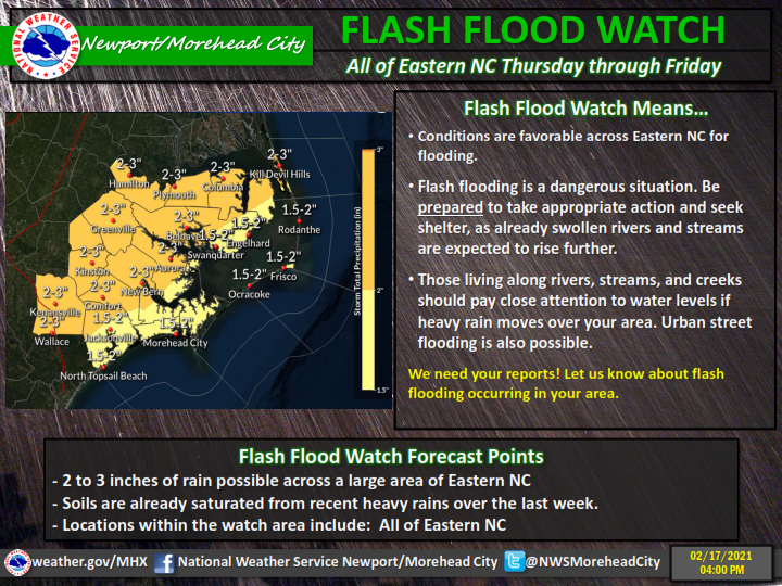
According to the National Weather Service in Newport/Morehead City, heavy rain expected this week. A train of low pressure systems will impact the region, bringing numerous rounds of heavy rain and storms beginning tonight through Saturday. The latest forecast calls for ***up to 6-10 inches of rain*** through the weekend, with locally heavier amounts possible. Flash flooding will be a concern all week. Keep your umbrellas handy this week and make sure to have multiple ways to receive warnings!
Periods of rain combined with already saturated soils, and rivers and tributaries already in flood stage, will result in additional river rises and flooding beginning tomorrow (Thursday), and lasting through Friday, before rain ends by early Friday evening. Occasional heavier rain bands could lead to localized flash flooding.
An area of low pressure will track across inland portions of the Carolinas into Virginia, dragging a strong cold front through the region late tonight into Tuesday morning. Strong thunderstorms will be possible ahead of the cold front late tonight into early Tuesday morning, mainly along the coast and east of US HWY 17. If storms become severe, the main threats will be damaging wind gusts, hail, and isolated tornadoes.
Local news delivered to your inbox every day at 7am. Free, always.