Hurricane Dorian: Latest from the National Weather Service
Graphic: weather.com
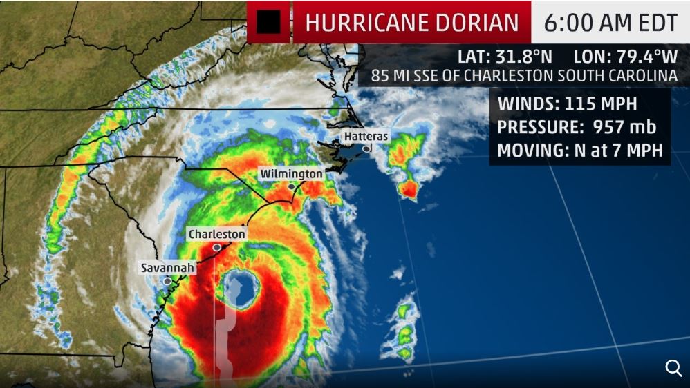
UPDATED 9-5-2019 5:00 AM
According to the National Weather Service, Hurricane Dorian is located at 31.7N 79.5W, which is about 80 miles SSE of Charleston, SC and about 200 miles SSW of Wilmington, NC. The storm has maximum sustained winds of 115 mph and is moving N at 8 mph. The minimum central pressure is 957 mb / 28.26 inches.
Graphic: weather.com

Graphic: weather.com

Graphic: weather.com

Graphic: weather.com
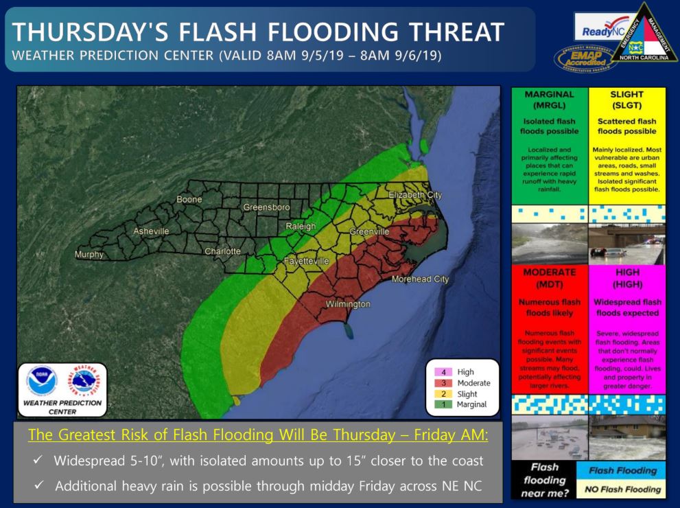
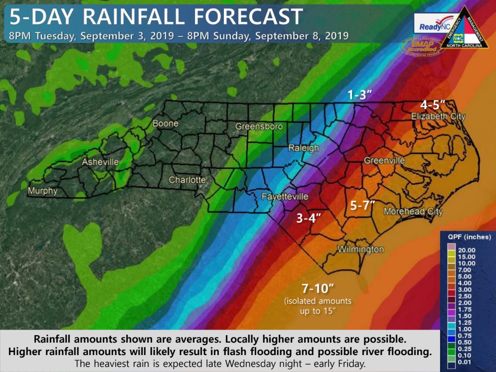
UPDATED 9-4-2019 5:00 AM
The National Weather Service in Newport/Morehead City has issued a Flash Flood Watch for a portion of eastern North Carolina, including the following areas, Coastal Onslow, Duplin, Greene, Inland Onslow, Jones, Lenoir, Martin, and Pitt from Thursday morning through Friday afternoon. Heavy rains associated with Hurricane Dorian will result in a Flash Flood threat for all of Eastern North Carolina Thursday into Friday. Storm totals of 6 to 8 inches of rain with locally higher amounts will be possible.
CURRENT WATCHES AND WARNINGS:
- A Tropical Storm Watch is in effect for Duplin, Greene, Lenoir, Martin, and Pitt
- A Hurricane Watch is in effect for Northern Craven
- A Storm Surge Watch and Hurricane Watch are in effect for Beaufort, Coastal Onslow, East Carteret, Hatteras Island, Inland Onslow, Jones, Mainland Dare, Mainland Hyde, Northern Outer Banks, Ocracoke Island, Pamlico, Southern Craven, Tyrrell, Washington, and West Carteret
According to the National Weather Service, Hurricane Dorian is located at 29.2N 79.5W, which is about 410 miles SSW of Morehead City. The storm has maximum sustained winds of 105 mph and is moving NNW at 8 mph. The minimum central pressure is 963 mb / 28.44 inches.


UPDATED 9-3-2019 1:00 PM


UPDATED 9-3-2019 11:00 AM
The National Weather Service in Newport/Morehead City has issued a Tropical Storm Watch for Lenoir and Greene Counties. A Tropical Storm Watch means tropical storm-force winds are possible somewhere within this area within the next 48 hours. Peak Wind Forecast: 35-45 mph with gusts to 60 mph. Window for Tropical Storm force winds: Thursday afternoon until early Friday morning.
The National Weather Service in Newport/Morehead City has issued a Hurricane Watch for Jones County. A Hurricane Watch means hurricane-force winds are possible somewhere withing this area within the next 48 hours. Peak Wind Forecast: 45-55 mph with guests to 70 mph. Window for Tropical Storm force winds: Thursday afternoon until Friday afternoon.

Source: National Weather Service Newport/Morehead City

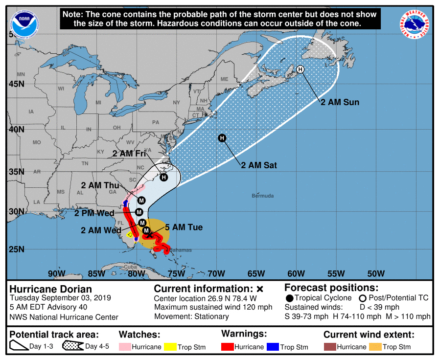
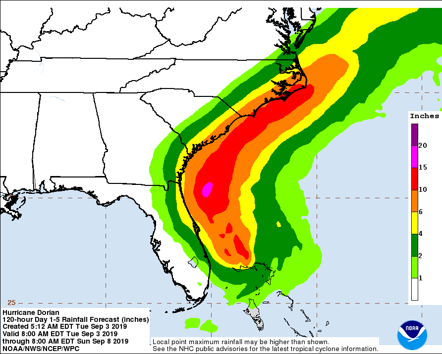
UPDATED 9-3-2019 5:00 AM
According to the National Weather Service, Hurricane Dorian is located at 26.9N 78.4W, which is about 35 miles Northeast of Freeport Grand Bahama Island and about 105 miles East of West Palm Beach, Florida. The storm has maximum sustained winds of 120 mph, wind gusts to 150 mph and is stationary. The minimum central pressure is 950 mb / 28.06 inches.

UPDATED 9-2-2019 6:00 AM
According to the National Weather Service, Hurricane Dorian is located at 26.7N 78.2W, which is about 35 miles East of Freeport Grand Bahama Island and about 120 miles East of West Palm Beach, Florida. The storm has maximum sustained winds of 165 mph, wind gusts to 200 mph and is moving West at 1 mph. The minimum central pressure is 916 mb / 27.05 inches.


Source: weather.com
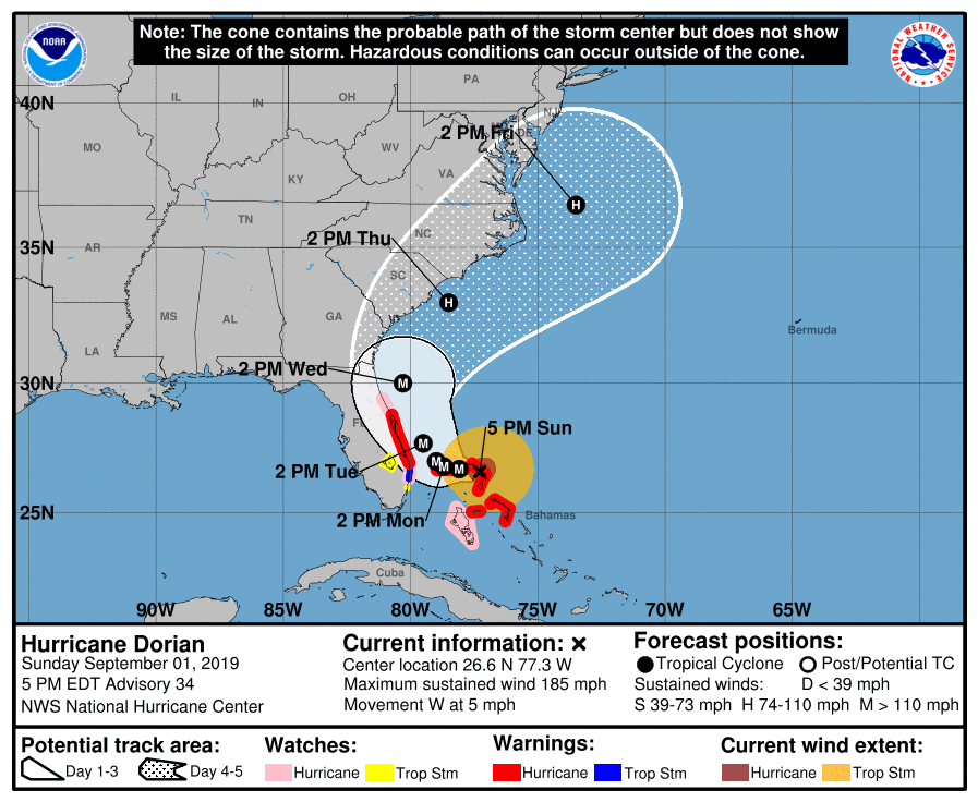
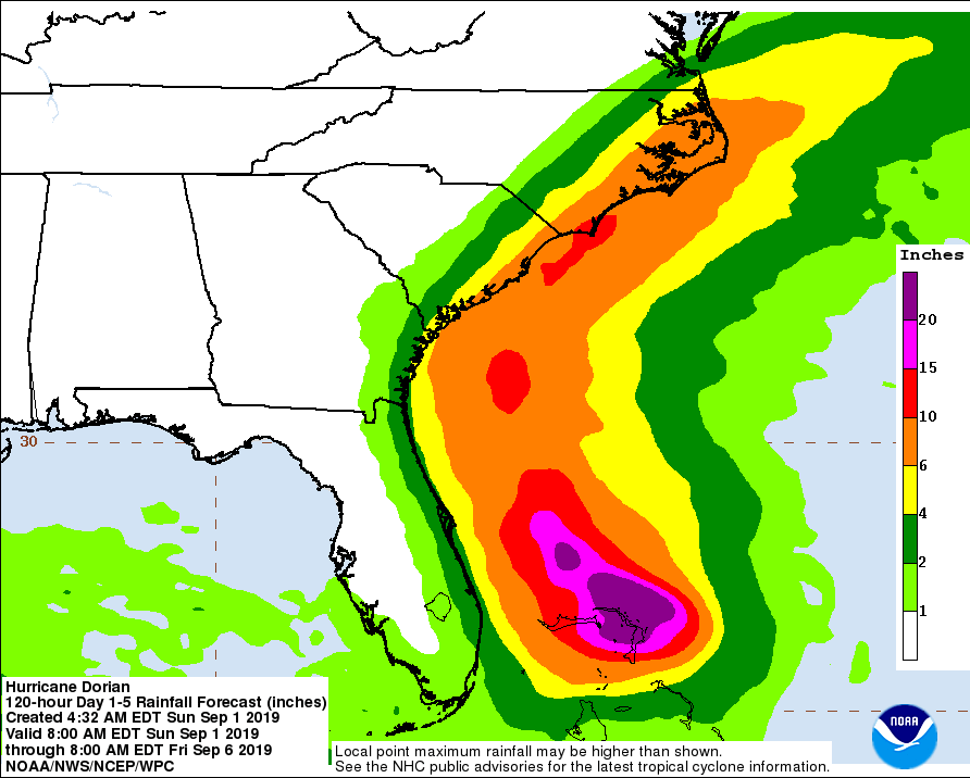
UPDATED 9-1-2019 5:00 PM
According to the National Weather Service, Hurricane Dorian is located at 26.6N 77.3W, which is about 95 miles East of Freeport Grand Bahama Island and about 175 miles East of West Palm Beach, Florida. The storm has maximum sustained winds of 185 mph and is moving West at 5 mph. The minimum central pressure is 910 mb / 26.88 inches.


UPDATE 9/1/2019 9:00 a.m.
According to the National Weather Service:
The hurricane continues moving westward, or about 280/7 kt. A high pressure ridge to the north of Dorian should maintain this westward movement through today. By tonight, the global models show the ridge weakening, and this evolution should result in a slowing of the forward speed, with the hurricane becoming nearly stationary around 48 hours. In comparison to its earlier runs, the new ECMWF track forecast takes the system farther to the west during the next couple of days, and is the southwesternmost model through 48 hours. As a result, the official track forecast has been shifted a little west during that time frame. In 2 to 4 days, Dorian should turn northward in response to a trough over the eastern United States. By the end of the period, the flow on the south side of the trough should cause the cyclone to move northeastward near the Carolinas.
LOCATION...26.5N 76.5W
ABOUT 35 MI...55 KM E OF GREAT ABACO ISLAND
ABOUT 225 MI...360 KM E OF WEST PALM BEACH FLORIDA
MAXIMUM SUSTAINED WINDS...160 MPH...260 KM/H
PRESENT MOVEMENT...W OR 275 DEGREES AT 8 MPH...13 KM/H
MINIMUM CENTRAL PRESSURE...927 MB...27.37 INCHES


UPDATED 8/31/19 11 :00 p.m.
According to the National Weather Service:
Data from both Air Force and NOAA Hurricane Hunter aircraft indicate that Dorian remains a very powerful hurricane, and the satellite presentation is still quite impressive with a very stable, well-defined eye. There has been no evidence of concentric eyewalls in aircraft or microwave data, which is somewhat surprising given that the intensity has been at category 4 strength for 24 hours. Both aircraft measured peak flight-level winds that support an initial intensity of 130 kt.
Dorian is forecast to continue moving over very warm waters and into a low-shear environment during the next 12-24 hours, so some additional strengthening is possible. Difficult-to-predict eyewall cycles, however, are likely to begin at some point within the next day or so and could cause fluctuations in intensity. After 72 hours, increasing southerly shear is likely to produce gradual weakening, but Dorian is forcast to remain a dangerous hurricane through the forecast period.