There will be daily chances for shower and thunderstorm activity from today through Thursday. A few these storms have the potential to become severe with the greatest risk for seeing severe weather occurring on Thursday.

All tagged weather
There will be daily chances for shower and thunderstorm activity from today through Thursday. A few these storms have the potential to become severe with the greatest risk for seeing severe weather occurring on Thursday.
NWS: Strong system has potential to produce severe weather Thursday, early Friday
Showers and a few embedded storms will overspread Eastern NC this morning. After a break in the widespread showers, additional scattered showers and thunderstorms may develop ahead of an approaching cold front from the west this afternoon.
Rainfall amounts have increased once again. Current forecast shows widespread rainfall amounts between 2-5 inches with locally higher amounts possible especially west of Hwy 17.
There is still some uncertainty in the amounts and location of heaviest rainfall and coastal impacts.
A strong, complex low pressure system will impact eastern NC this weekend bringing the potential for heavy rain (Friday night and Saturday), isolated strong to severe thunderstorms (Saturday), strong winds, coastal flooding and dangerous marine conditions.
A frontal system impacting our area this weekend is capable of bringing strong to marginally severe thunderstorms, heavy rainfall, strong wind gusts, and sound-side coastal flooding.
We are expecting a period of strong (Gale Force) northerly winds beginning tonight and continuing into Wednesday morning.
We are expecting strong to severe thunderstorms, strong winds, dangerous marine conditions, and minor coastal flooding for Eastern NC Friday evening into Saturday (January 12-13th.
A strong cold front that will impact eastern NC tomorrow and Wednesday.
There is high confidence that a strong low will impact the area this weekend into early next week, with impacts beginning to come into better focus.
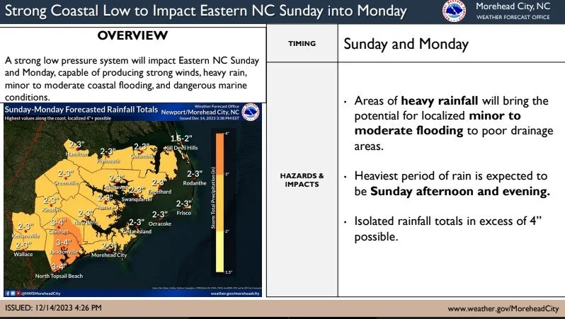
A strong low is forecast to impact eastern NC Sunday into Monday. There is an increased likelihood for several impacts from this system including localized flooding, gusty winds, dangerous marine conditions, and coastal impacts.